The Core Difference
LiDAR is an active sensor: it makes its own light, firing laser pulses and timing their return, so each point is a direct physical measurement. Because it brings its own light, it works at night and is unfazed by shadows.
Photogrammetry is passive: it only records the light already in the scene, then infers 3D geometry from how features shift between overlapping photos. That makes it cheap and colorful, but dependent on good lighting and visible surface texture.
That one distinction — measured versus computed — cascades into every practical trade-off below.
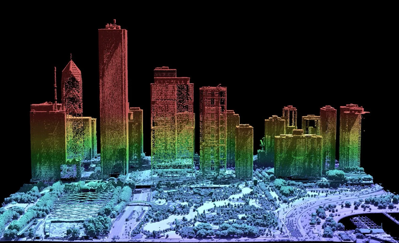
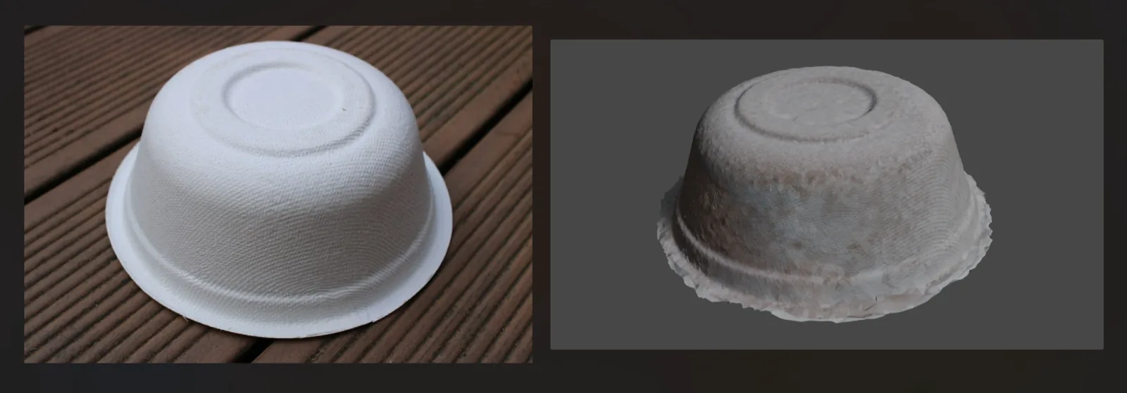
Two captures of a built environment. The LiDAR cloud (left) is a direct geometric measurement — precise structure even in poor light. The photogrammetric model (below) reconstructs both shape and photoreal texture from ordinary photos.
Side by Side
| Factor | LiDAR | Photogrammetry |
|---|---|---|
| Method | Active — laser ranging | Passive — photo reconstruction |
| Lighting | Any — works in the dark | Needs good, even light |
| Vegetation | Penetrates — sees bare earth via multi-return | Sees only the canopy surface |
| Color / texture | Limited (intensity; color often added from photos) | Photoreal true color & texture |
| Featureless / shiny surfaces | Handles them fine | Struggles (blank walls, glass, water) |
| Equipment cost | Higher (laser sensor + GNSS/IMU) | Low — any good camera or drone |
| Accuracy | High & consistent, well characterized | Good, but depends on capture & control |
| Data volume / processing | Large clouds; lighter processing | Heavy compute to reconstruct |
| Speed in field | Fast capture, immediate range | Fast to shoot, slower to process |
When LiDAR Wins
- Under vegetation — forestry, terrain under tree cover, floodplain mapping. Multiple returns reach the ground a camera never sees.
- Low or no light — night surveys, tunnels, mines, interiors without good lighting.
- Featureless or reflective scenes — bare walls, smooth concrete, metal, where photo matching fails.
- Highest, most predictable accuracy — engineering and survey deliverables where the error budget must be tight.
- Long range & large areas fast — corridor and airborne mapping at speed.
When Photogrammetry Wins
- Budget and accessibility — a drone or camera you already own, no laser scanner required.
- True color & visual detail — inspection, marketing, heritage, and anything where appearance matters.
- Small objects & close range — artifacts, components, and detailed textured models.
- Well-lit, well-textured sites — stockpiles, open construction, rooftops, quarries in daylight.
- Orthomosaics & maps — distortion-corrected aerial imagery you can measure off directly.
Accuracy is not just about the sensor
A well-flown photogrammetry mission with solid ground control can rival LiDAR on an open, textured site — while a rushed LiDAR job with a weak GNSS solution can disappoint. Capture discipline and control often matter as much as the technology you chose.
Better Together
The framing is rarely truly either/or. The two methods are complementary, and combining them is increasingly the norm:
- LiDAR + photos — lasers capture precise geometry while cameras supply photoreal color, draped onto the cloud. Many sensors collect both at once.
- Photogrammetry for color, LiDAR for ground — in vegetated terrain, LiDAR finds the bare earth and photogrammetry textures the surface.
- Add Gaussian splatting — for a photoreal, real-time walkthrough on top of the measurable geometry from the other two.
Quick Picker
Choose LiDAR if…
- There is vegetation to see under
- Light is poor or absent
- Surfaces are blank or shiny
- You need tight, proven accuracy
Choose photogrammetry if…
- Budget is the constraint
- Color & texture matter
- The site is open & well lit
- You want orthomosaics/maps
Use both if…
- You need geometry and color
- Terrain mixes cover & open ground
- The deliverable is a digital twin
- Accuracy and realism both count
Still scoping a capture? NDEVR works across LiDAR hardware and photogrammetry workflows — start with our guide to choosing a LiDAR system, or read up on the types of LiDAR to match a sensor to the job.